Two weeks before the official start to Atlantic hurricane season, Tropical Storm Arthur has become the first named storm of the year.
Warm Gulf Stream Waters
The tropics are heating up around the world
At a Glance
- Tropical Storm Arthur is tracking off the Southeast coast.
- Arthur will pass near North Carolina’s Outer Banks with rain and wind on Monday.
- A tropical storm warning has been issued.
- Rough surf and dangerous rip currents are expected along much of the Southeast coast.
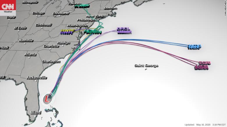
Tropical Storm Arthur is tracking off the Southeast coast and will pass near North Carolina’s Outer Banks on Monday with rain and gusty winds.
Arthur is centered over 300 miles south-southwest of Cape Hatteras, North Carolina, and is moving to the north-northeast.

A tropical storm warning has been issued for portions of the North Carolina’s Outer Banks from Surf City to Duck, including Pamlico and Albemarle Sounds. This means tropical storm conditions (40 mph or greater winds) are expected somewhere in the warning area within the next 36 hours.
Winds over 40 mph are possible in eastern North Carolina by late Sunday night or early Monday morning. The winds could break some tree limbs or cause isolated power outages.
Rainfall could total 1 to 3 inches in coastal sections of eastern North Carolina. Some bands of rain and gusty winds from Arthur could reach as far north as the Virginia Tidewater and the Delmarva Peninsula on Monday.
Arthur will also generate swells from the east coast of Florida to the Southeast and mid-Atlantic coasts the next few days. That will result in life-threatening surf and rip currents in these areas and beachgoers are advised to stay out of the ocean.
Minor flooding from storm surge is possible in low-lying areas of eastern North Carolina.
Impacts So Far
Miami and Ft. Lauderdale took the brunt of the heaviest rain as the system curled around South Florida.
Rain fell at the rate of almost 2 inches per hour, triggering a flash flood warning for Miami-Dade County, where street flooding was reported to be widespread, according to the National Weather Service.
A severe thunderstorm brought lightning and gusty winds to the metro area again Saturday evening.
Preseason Storms Have Been Common Lately
Arthur is another example of how storms can sometimes form before the hurricane season officially begins on June 1. This is the sixth straight hurricane season that has started early.
Since 2015, at least one named storm has developed before June 1 each hurricane season, some of which had impacts in the United States and elsewhere in the Atlantic Basin.
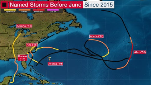
Last May, Subtropical Storm Andrea formed southwest of Bermuda the week before Memorial Day, but only lasted about 24 hours.
In 2018, Tropical Storm Alberto made a Memorial Day landfall along the Florida Panhandle, remained intact and took a strange track into Lower Michigan before losing its tropical characteristics.
Tropical Storm Arlene developed even earlier than Alberto and, in 2017, became only the second April Atlantic tropical storm of record.
Perhaps 2016 was the strangest early start to an Atlantic season in recent memory.
Tropical Storm Bonnie soaked the coast of the Carolinas in late-May 2016. But that was preceded by eastern Atlantic Hurricane Alex, only the second known January Atlantic hurricane. Alex eventually made landfall in the Azores as a tropical storm.
In 2015, Tropical Storm Ana made the second-earliest U.S. landfall of at least a tropical storm on record on Mother’s Day weekend along the coast of the Carolinas.
This early start also happened in 2012 (Alberto, then Beryl in May), 2008 (Arthur), 2007 (another Subtropical Storm Andrea) and 2003 (another Ana, this time in April). Beryl nearly became a hurricane before coming ashore near Jacksonville Beach, Florida, on Memorial Day weekend 2012.
Nine of 17 years from 2003 through 2019 had at least one named storm before June 1, and there were a total of 11 out-of-season named storms during that time. The majority of these developed and meandered, or made landfall along the coast from North Carolina to northeastern Florida.
To track the progress of the tropical storm click here
Credit: Source link